


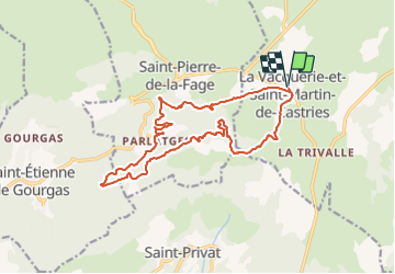
Herault - La Vacquerie-et-St-Martin-de-Castries 18km 635m

RandoVal
User

Length
18 km

Max alt
793 m

Uphill gradient
550 m
Km-Effort
25 km

Min alt
409 m

Downhill gradient
550 m
Boucle
Yes
Creation date :
2018-09-12 19:08:54.554
Updated on :
2018-09-12 19:08:54.565
5h37
Difficulty : Difficult

FREE GPS app for hiking
 SityTrail
IGN / Geographical institutes
SityTrail Plus
The world is yours!
About
Trail Walking of 18 km to be discovered at Occitania, Hérault, La Vacquerie-et-Saint-Martin-de-Castries. This trail is proposed by RandoVal.
Description
Boucle dans la forêt de Parlatge. départ parking rando de La Vacquerie.Sens
anti-horaire. Version moyenne
Positioning
Country:
France
Region :
Occitania
Department/Province :
Hérault
Municipality :
La Vacquerie-et-Saint-Martin-de-Castries
Location:
Unknown
Start:(Dec)
Start:(UTM)
536901 ; 4848735 (31T) N.
Comments